Léfkes - Pródromos and back (the Byzantine road)
Evaluation: This is the classic walk on Paros, the so-called "Byzantine road" part of an old medieval path. It is one of the few walks on the Cyclades where you can meet large groups of walkers! The route is pretty well marked with a trail marker [1], but as so often, the starting point is not so clear, both in Léfkes and in Pródromos. The hike deserves an evaluation of ***.
Estimated time: The actual walking time is a little over one hour until Pródromos and the return route takes also just over one hour. But while the actual walking time is in total about 2h15, the TWT (total walking time) soon mounts to 5 hours - we walked from 11am to 4pm, with a lunch at the restaurant on the platía of Pródromos.

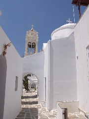
The house with the bell Léfkes.
You have to go to the far right and after 20 meters you see the first sign pointing to the Byzantine road.

A little sign to the byzantine road.
You veer a little to the right and a bit further you arrive at a second sign, next to a little church. So you go left and you continue to follow the picturesque and descending street - and all of a sudden you notice a trail marker [1] on a wall of this beautiful street.

A street in Léfkes, at the betinning of the walk [1].
You reach a clearing with a little concrete road in front of you – on the left of this road, you find the beginning of the trail (signs and the trail marker [1]).
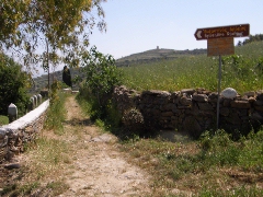
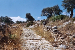
The beginning of the Byzantine road from Léfkes to Pródromos.
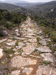
(0h21) A little less than fifteen minutes after the start of the path you already reach the highest point, and soon thereafter there is the beginning of a long stretch, slightly going downwards, which is nicely paved - Náxos lies before you.
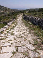
The marvellous pavement of the byzantine road: a look behind you (left) and before you.
The path is still very nice and you can see it before you as it continues on the slope before you. First, however, you descend into a side-valley and you cross a nice bridge.
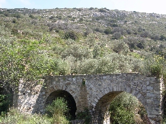
A nice bridge between Léfkes and Pródromos.
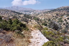
(0h31) You climb up on the other side, and after a beautiful stretch of about 16-17 minutes, you almost reach the top. The path then gets narrower and rockier. You cross the hill top and the plain emerges before you: to the left you see the hill of Galiós and to the right the height of Kéfalos with Agios Antónios. At the foot of this hill lies Mármara (to the left), Márpissa (higher and to the right) and Pródromos (closer to you) - and you can see quite nicely how the path goes down to that village. In the sea you can distinguish Naxos, Irakliá to the right and Ios on the far right.
(0h42) The pavement starts again for about 5 minutes and then the path gets rockier again. After another six minutes and a final little stretch of pavement, you come to a gravel road, running alongside the wall of the first house. Sometime later you reach a little concrete road, where you go left – but you turn right immediately thereafter. After another 2-3 minutes you reach a crossroad next to the wall of a house [1] and you take a left. A little further, you come again to a crossroads, with before you a map of Pródromos and a no. [1] on a pole: you go right, then you take the little street off the left, you continue straight ahead and so you come to a passage under a tower.
You pass under the tower...
Further on, you go left and then right again, you curve right and left again, you go through a kamára (vaulted passage) under bells, and you finally arrive at the square. (1h05)
After a little under 5 minutes you reach the concrete road (with on the right the map and a no. [1]), and you take a left.
(1h11) After 1 minute, you keep a little to the right [1] and after another few minutes you reach the beginning of the path, on the right: at first it is a small gravel road (sign "Byzantine path" and [1]). From now on the path is unambiguous! Pretty soon you come to the right of the wall near the house and you start to walk up, at first on a nice pavement; further on, the trail is stony or rocky. After a while you climb faster, alternately on paved or on rocky stretches, and so you come near the top. You then reach a really beautiful and paved stretch - a real kalderími: the path used to be quite wide here, but it is partially overgrown or ruined.
Looking behind you towards Pródromos.
The kalderími in the direction of Léfkes.
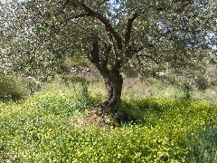
In Spring, you continue midst olive trees and flowers...
However, the most beautiful part of the broad kalderími is yet to begin, midst olive trees and other greenery. At first the climb is fairly steep, but later on it gets more gradual – all together the climb takes a little over 11 minutes, before you reach the hill crest; Léfkes is much closer now.
The nice byzantine path to Léfkes.
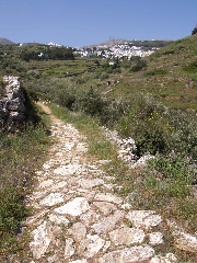
(1h51) At this point you get to the end of the beautiful pavement, after a wonderful stretch of about 18 minutes. You reach a sandy path, with a beautiful view over the east side of Léfkes and the large amount of cypresses.
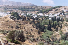
Panoramic view on Léfkes.
You descend and you go up again, the great church is now on your right and you end up in the western part of Léfkes, on the left-hand side of the valley.
(2h06) You arrive at the place where the concrete road ends, but you go to the far right and then you continue straight ahead through the village. After 2 minutes, you reach a crossing where you continue on the left of the chapel. By keeping to the left, you come alongside another chapel – with even more to the right the big church of Agia Triáda. On the corner of the house with the large bell, you take a left and a little further you go down on the right – a little later however, you go up on the right again. Next to a cypress tree, you go up on the right and then you continue straight on. Finally, you arrive at the bend of the paved road near the bus stop. (2h13)